Grayburg Presents Big New ROZ Target
By L. Stephen Melzer, Robert C. Trentham and Trey Kimbell
MIDLAND, TX.–The Permian Basin region has been under dual spotlights of late with its shale and horizontal plays (Wolfberry, Cline and Bone Springs), as well as its 11 ongoing carbon dioxide enhanced oil recovery projects that have been implemented to produce commercial volumes from so-called residual oil zones (ROZs)–large “naturally waterflooded” reservoirs that would not produce oil in either the primary or secondary phases of production.
The ROZ opportunity revolves around the newly gained observations that EOR can liberate residual oil in commercial quantities from a formation when the mobile phase is entirely water. It is further enhanced by the recently developed understanding that the large thickness of ROZs can be commercially flooded, that the ROZs are very widespread, and that they can exist where no main pay (mobile oil zones) intervals overly them. A new phase of basin development is now likely with the augmentation of residual oil reserves underlying the main pay zones (MPZs), which have been producing oil for eight decades.
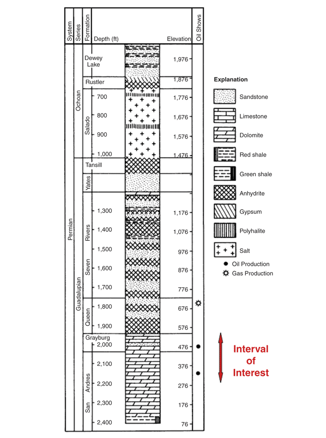
FIGURE 1
Typical Stratigraphic Column along the Ozona Arch
Source: After W.E. Galloway, et. al. (“Atlas of Major Texas Reservoirs,” University of Texas at Austin, Bureau of Economic Geology, 1983).
The commercial ROZ demonstrations to date all have been conducted in the prolific Permian-age San Andres formation (Figure 1). However, recent work is now examining other formations. This article examines the results of one such study in the overlying Grayburg formation. The case study field–the World (Grayburg) Field in Crockett County, Tx.–is demonstrating interesting results when compared with ROZ attributes of the benchmark San Andres formation. As is often the case, branching away from a study of one particular formation or area often leads to a better understanding of the science and to better reservoir target definitions.
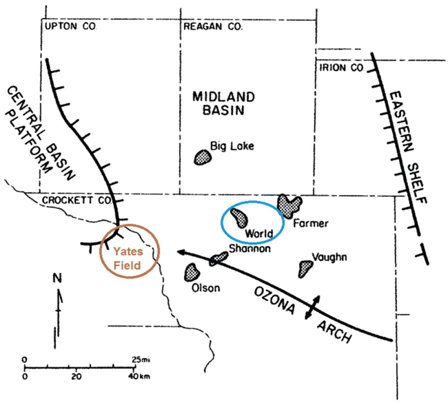
FIGURE 2
Map of World Field and Location
Of San Andres/Grayburg Reservoirs on Ozona Arch
Source: After Galloway, et. al.
The World Field is located within a cluster of fields in the southern part of the Midland Basin and alongside or just north of the Ozona Arch (Figure 2). It is one of the earliest field discoveries in the Permian Basin, first found in 1925 and originally designated the Powell Field (later designated the World-Powell Field, and finally, the World Field). The primary producing zone is the Grayburg reservoir, which is composed of a series of high-energy dolomitized ooid shoals and associated subtidal facies, as are typical of Grayburg formation fields on the Ozona Arch. The Grayburg is normally less than 250 feet thick; the pervasively dolomitized carbonate interval extends downward an additional 100 feet into the Upper San Andres.
In the World Field, as in other Grayburg-San Andres fields on the Ozona Platform, there are a series of dolomitic limestone wedges that extend down dip to the north-northeast off the crest of the Ozona Platform and into the southern Midland Basin, which interfinger with basinal clastics. The deeper intervals are thought to be the ROZ fairways below the upper zones and stratigraphic fingers with free oil traps on the apex of the structure and northeast flanks of the arch.
The World Field has not seen a mineral rights unitization initiative, but is primarily controlled by a single operator (Burk Royalty), which holds most of the leases to the Grayburg/San Andres intervals. Waterflooding has occurred in the field, but injection activity can be characterized as more of a water disposal operation in contrast to classic pattern flooding.
World Field ROZ Potential
The benchmark work on the origins of residual oil zones has identified three differing sources of natural waterflooding of a previous oil entrapment: post-entrapment tilting, breached and reformed sealing, and lateral (hydrodynamic) flushing. Studies have identified lateral flushing as the predominant source in the Permian Basin. The lines of evidence are tilted oil/water contacts caused by the hydrodynamic gradients, and alignment of ROZs along fairways of sweep.
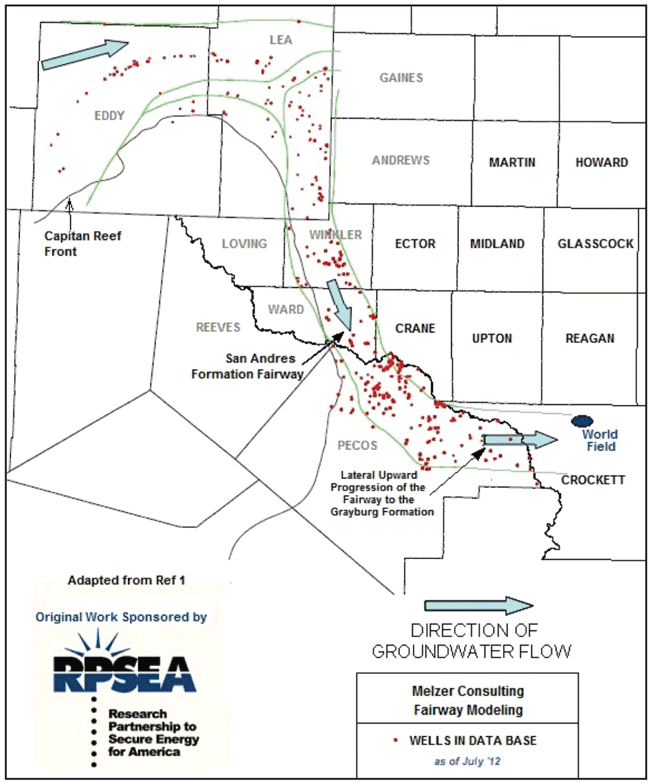
The most recent work, sponsored by the Research Partnership to Secure Energy for America and conducted by The University of Texas of the Permian Basin, Melzer Consulting and Arcadis (“Commercial Exploitation and the Origin of Residual Oil Zones: Developing a Case History in the Permian Basin of New Mexico and West Texas,” Contract 81.089 08123-19-RPSEA [www.rpsea.org/ 0812319]), gathered drill stem test, drilling, and water sample data, and modeled the hydrology of what has come to be called the “Artesia Fairway.”
Figure 3 depicts the key well data points involved, the lateral limits of the Artesia Fairway while extending the fairway to the east into the area of the Ozona Arch and the World Field. Data acquisition to the east of Pecos County was not part of the study.
There are several important pieces of evidence to discern the presence of an EOR ROZ target. Some of the best are cuttings with good odor, cut, fluorescence and gas shows. In addition, calculations of 20 percent or higher oil saturations from logs, 15-40 percent oil saturations from core tests, a strong predominance of dolomite over limestone, and production of sulfur water on drill stem tests or completions are also key indicators. As mentioned, tilted oil/water contacts (tilting downward in the direction of the flushing water flow) is another. Enhanced porosity and permeability below the typical mobile oil intervals is yet another.
Knowing what we now understand about the Permian Basin, several key quotes in “Occurrence of Oil and Gas in West Texas”–the 1957 publication from the Bureau of Economic Geology at the University of Texas at Austin that remains a recognized standard for describing the basin’s geologic setting (Frank Herald, editor; Pub. No. 5716)–would have signaled the presence of residual oil zones in the World Field. In the Grayburg interval, Herald stated that “anticlinal folding is the dominating trap-forming factor, the trap is due partly to the lensing of porous zones in the reservoir rock on the east side of the field.”
He also went on to say, “The sum thickness of zones of (primary) productive rock (in the Grayburg) ranges from two up to 65 feet. However, penetration of reservoir rock in the productive wells averages only about 10 feet due to the precaution to avoid unnecessary production of water.” The sum total of these observations has the unmistakable signature indicating the presence of a ROZ.
Analog CO2 EOR Projects
The excitement surrounding CO2 EOR has risen to a new level in recent years. Three factors are contributing:
- Higher tiers of oil pricing;
- Interest in finding a subsurface home for anthropogenic CO2 that otherwise would be emitted to the atmosphere; and
- The awareness that large, new commercial reservoir targets exist below the oil/water contact in many fields.
However, the level of appreciation for ROZ potential is not yet widespread in the industry, with the excitement of unconventional shale plays seizing the imagination of operators. The expansion of CO2 EOR moves more slowly both because of the capital-intensive nature of the business, and the limitations on CO2 supply and pipeline infrastructure that exist in all regions of the United States and around the world. But the growth is unmistakable and will have perhaps the most long-lasting impact on energy security and the total U.S. reserve base.
Two field analogs are especially useful to establish the promising future of the World (Grayburg) EOR project. The first demonstrates the commerciality of the ROZ in the Seminole San Andres Unit (SSAU), a Gaines County, Tx., field operated by Hess Corporation and the most fully documented project to use as a benchmark. Four separate EOR ROZ projects have been implemented at SSAU to produce oil from below the oil/water contact. The 500-acre Phase I pilot was implemented in 1996 and produced a peak oil response of 1,500 bbl/d and an estimated 2 million barrels of cumulative crude oil produced to date from the 300-foot interval of the Phase 1 ROZ project.
A second pilot (Phase II) was implemented in 2004 on closer well spacing and demonstrated the expected faster oil processing rates and a similarly significant oil response. The success of the ROZ pilots led to full-scale, fieldwide ROZ deployment. Hess is executing the third post-pilot stage with ROZ oil production already climbing to more than 8,000 bbl/d, and the company is preparing to implement a fourth stage of the fieldwide expansion.
The second benchmark project is an Exxon (now XTO) CO2 EOR project in Andrews County, Tx. Although a main pay zone flood, the Means Grayburg/San Andres flood is especially significant in that the oil characteristics are the most similar to the oil present in the World (Grayburg) Field. The MPZ at Means Field possesses an unusually high-viscosity (6.0 centipoise) and lower-gravity (29 degree API) oil in comparison to the normal San Andres projects. The quoted gravity for the oil at the World Field is slightly less than the Means Field, while the viscosity is slightly higher.
The viscosity decrease and oil mobility enhancement of a heavier, viscous oil when taking into solution the CO2 has been concluded as a key contributor to the greater-than-expected (more than 20 percent of original oil in place) CO2 EOR recoveries witnessed at Means. The mobility ratio for waterflooding was detrimental to high recoveries during the waterflood, as considerable oil was bypassed by the water. The evidence suggests that the natural waterflooding of the Grayburg oils at the World Field creating the ROZ have had the same net results (i.e., leaving a large post-waterflood target) and the type of oil in the World Field will be especially responsive to mobility enhancements using CO2.
Table 1 compares the field characteristics of the two analogs, Seminole ROZ and Means MPZ, with the World (Grayburg) ROZ opportunity.
ROZ Log Evidence
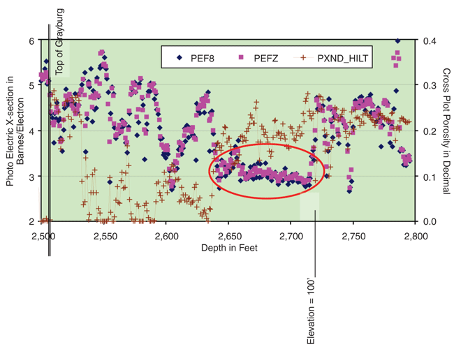
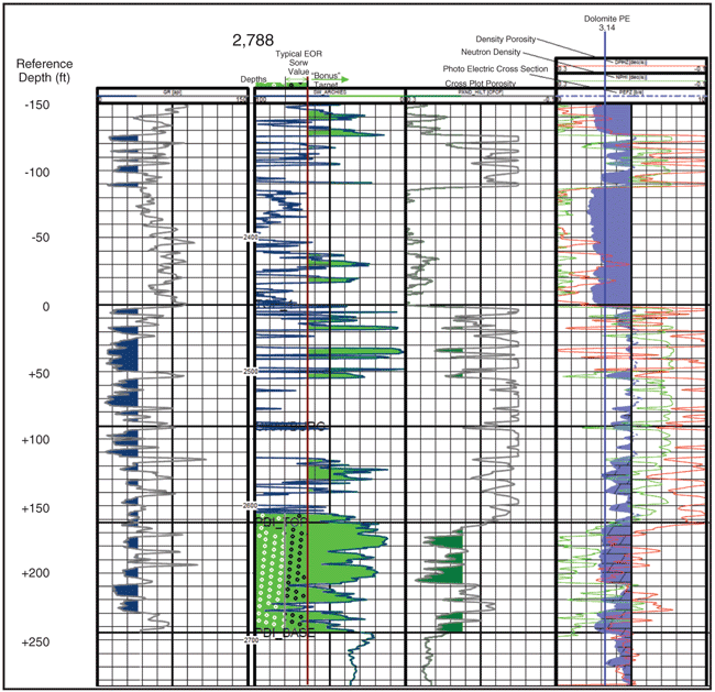
One of the most significant indicators of a residual oil zone has been shown to be the presence of a thick and pervasively dolomitized section. Figures 4 and 5 demonstrate the nature of this interval utilizing various wireline logs, but especially the photoelectric cross-section log from the World Field. This particular tool discriminates the dolomites (a photoelectric index value of 3.14) from the often-interspersed limestones and anhydrites (values slightly greater than 5.0).
The evidence of thoroughly dolomitized intervals is valuable and the presence of oil in cuttings or core is useful, but the level of residual oil saturation (Sor) values is a key to the economics of the EOR flood. Figure 5 provides the Archie calculations from a well in the World Field. Note the very low values for the ROZ interval (corresponding high values for 1-Sw = So).
Also note that the typical oil saturations are in excess of the commercial benchmark of 35 percent (the 35 percent Sor line is colored in this figure). Average interval ROZ target values are typically in the 25-35 percent range, so this ROZ ranks as extremely high. In fact, a 45 percent value in calculations of oil in place is being used for the World Field ROZ.
The more recent work on defining the residual oil zones has been exclusively examining the San Andres formation, and largely overlooking the overlying Grayburg formation. Some evidence now exists that the heavier oil, as evidenced in certain fields, can lead to a large ROZ opportunity in the Grayburg. The evaluation of the Burk Royalty-operated World Field demonstrates that the ROZ may provide a better EOR economic opportunity than main pay zone waterfloods because of the incrementally better porosities and permeabilities, and their large values of residual oil saturation by waterflooding in the swept zone (Sorw).
L. STEPHEN MELZER is a consulting engineer in Midland, Tx., specializing in CO2 injection and enhanced oil recovery projects. With 25 years of industry experience, he formed Melzer Consulting in 1997 to advise clients in both the public and private sectors on the multifaceted business issues in the CO2 EOR and carbon capture and storage markets. Before establishing Melzer Consulting, he operated a small independent oil and gas company. Melzer is president of the Texas Carbon Capture and Storage Association, director of the annual CO2 Flooding Conference, co-director of the annual EOR Carbon Management Workshop and was on the advisory board for the FutureGen Project for Texas. He is a past president of the Applied Petroleum Technology Academy, and previously served as director of The University of Texas of the Permian Basin’s Petroleum Industry Alliance and as co-chairman of the University of Texas School of Law’s continuing education conferences on carbon and climate change.
ROBERT C. TRENTHAM is a senior lecturer in geology at the University of Texas of the Permian Basin and director of the Center for Energy & Economic Diversification at UTPB. Before joining UTPB in 2001, Trentham served as a consulting geologist at Muskoka Consultants in Midland, Tx. Prior to that, he was a senior geologist at Chevron U.S.A. and a project geologist at Gulf Oil Co. He is past president of the Midland Energy Library, West Texas Geological Society, and the Permian Basin Section of the Society of Economic Paleontologists and Mineralogists. He is president-elect of the Applied Petroleum Technology Academy. Trentham is principle investigator or co-principle investigator of a number of U.S. Department of Energy-sponsored research projects related to residual oil zones. He holds a B.S. and an M.A. in geology from the City College of New York, and a Ph.D. in geology from the University of Texas at El Paso.
TREY KIMBELL is a geologist at Burk Royalty Company in Wichita Falls, Tx. He marks the fourth generation of the Kimbell family to work at Burk Royalty. His responsibilities include various roles of mapping, petrophysical and formation evaluation, and developmental geology for the company’s assets in East Texas and the Permian Basin. Prior to joining Burk Royalty, Kimbell began his career as a staff geologist for Quicksilver Resources in Fort Worth, where he was part of the Southern Barnett Shale division.
For other great articles about exploration, drilling, completions and production, subscribe to The American Oil & Gas Reporter and bookmark www.aogr.com.


